Updated corrosion mapping essential for reshaping SA’s urban and rural infrastructure planning
6 min read
South Africa’s updated corrosion map is not only useful, it is essential in reshaping infrastructure strategy, and will impact on urban and industrial planning and maintenance – as well as the design of iconic future structures, believes Anthony Botha, marketing manager at Hot Dip Galvanizers Association of South Africa (HDGASA).
“The updated map moves beyond a generalised idea of the climate and is far more strategic. It plays a very large role in feasibility studies, identifying the best siting for facilities, how these should be built and what corrosion control measures must be applied,” he explains.
He observes that, had today’s corrosion mapping been available ahead of the 2010 FIFA Soccer World Cup, stadiums might have been built differently. However, better information will make for wiser future urban and rural planning decisions.
The new corrosion map will also support the training and advisory services provided by the HDGASA for designers, engineers, procurement managers, specifiers and construction companies.
“For example, in the current solar photovoltaic race to the top, we are bringing people into line with the current understanding of corrosion control environments for renewable energy development.”
Mapping the invisible adversary
As Botha explains, the durability of steel is constantly challenged by an invisible adversary: atmospheric corrosion. Moisture, pollutants and salt-laden air all silently undermine structural integrity, shorten service life and inflate maintenance costs.
“The HDGASA assists in determining rates of corrosion for newly designed hot-dip galvanised steel structures. The quantum of queries centres on the macro- and micro-atmospheric environments in South Africa.”
The initial corrosion map, released in 1991, was heavily weighted toward coastal data.
Over the years, Botha says the HDGASA noticed the impact of climate change and micro-environmental differences: “We have seen this particularly in Gauteng, where the impact of pollution drove some of the highest rates of corrosion in both Sasolburg and Germiston. They were in the middle of what was considered a relatively stable C3 environment.”
Following the 2019 publication of a comprehensive update to South Africa’s national corrosion map in the South African Journal of Science, this became a C5 environment.
“In Germiston, the use of galvanised rebar suddenly made more sense than just plain rebar, because the environmental conditions became much harsher than previously,” Botha explains.
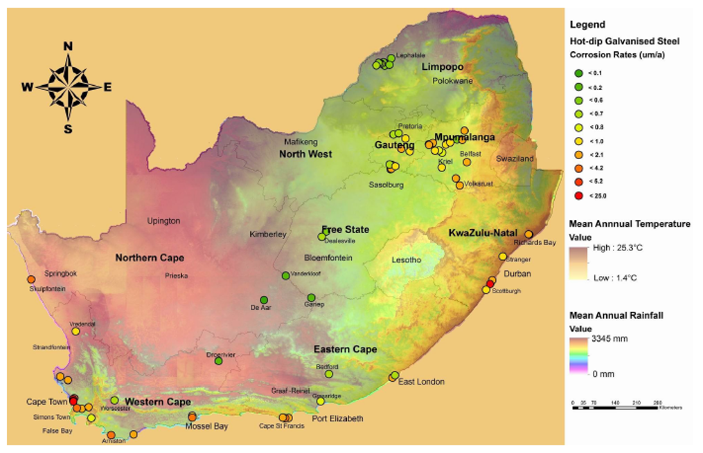
While the original information was derived from 15 to 19 sites, the 2019 update analysed over 100. Together with the corrosion rate of zinc in SANS ISO 9223, a clear corrosion map of inland microclimates can now be used to ensure effective specification of hot-dip galvanising.
The findings revealed striking variability:
- Inland corrosion rates ranged from as low as 1.3µm/year in the arid Droërivier region to over 50µm/year in industrial hubs such as Germiston and Sasolburg.
- Coastal zones showed steep gradients in corrosion severity, with rates dropping by up to 80% within the first kilometre from the shoreline.
- Altitude, humidity and SO₂ levels emerged as key modifiers, especially in high-traffic or industrial zones.
Engineering meets strategy for new builds and asset protection
Botha notes the updated corrosion map supports more accurate classification of corrosivity zones using the SANS ISO 9223 standards – enabling tailored decisions for coating selection, inspection intervals and refurbishment planning.
For example:
- In low-corrosivity inland zones (C2–C3), standard hot-dip galvanised coatings (≥85µm >6mm thick steel]) may deliver over 30 years of corrosion control with minimal maintenance.
- In high-corrosivity coastal or industrial zones (C4–C5), thicker coatings or duplex systems may be required to achieve comparable durability.
- Inspection intervals can be optimised based on zone severity, ranging from five to 20 years depending on exposure and coating type.
“These insights are especially valuable for engineers managing ageing infrastructure, where decisions about refurbishment, replacement or protective upgrades must be grounded in environmental reality,” he says.
In a country where infrastructure spans deserts, coastlines, industrial belts and high-altitude plateaus, this level of insight is not just useful but essential. For instance, a galvanised steel structure (>6mm thick steel) in a C3 inland zone may well retain over 70µm of zinc coating after 25 years – while the same structure in a C5 coastal zone may require re-coating or replacement within 15 years.
“Often, corrosion control is determined by cost. By using inaccurate information for a particular micro-environment, an architect or designer could be under- or over-designing – which could give rise to additional costs in the long term.”
Mapping the future
Corrosion mapping could also impact on the evolving circular economy. Without factoring in the micro-environment in which the steel is initially used, corrosion could be too advanced for galvanisation or re-use of steel.
This corrosion mapping update also brings South Africa in line with global best practices, as similar approaches are used in the United Kingdom, Australia, New Zealand and Japan.
In conclusion, Botha advises that corrosion evaluation is incorporated in all the HDGASA’s training courses – and that corrosion evaluation research is necessary in sub-equatorial Africa, as South African companies are increasingly active across this region.
Main image credit: Freepik/nuraghies